Friday, February 23, 2007

West Coast travel notes

This post is just a sampling of photos we happened to take while traveling to see family and friends. There's not much rhyme or reason to what we "shoot" and what we don't when we're not specifically trying to make memories and share them with family and friends. But I did say I'd throw in some of these here, so here they are:

Skiing with Jolene's dad, Ivan Bauer, at Tahoe. Jolene wanted to take her ski equipment, so I packed my stuff, too. And a good thing it was! We had about the best day of skiing I can remember -- midweek lift lines, great weather, great snow, and great company!

Being in the neighborhood, we dropped in on the annual "Egg Drop" contest at my alma mater, Walla Walla College. The "Egg Drop", sponsored by the ASME (American Society of Mechanical Engineers), is one way of drawing the public into the challenges of engineering design. The contest is open to all, with the simple goal of conveying a raw egg from a height to the ground, by force of gravity, without breakage. Prizes are awarded in various categories such as "Closest to Target", "Lightest Packaging", and (my favorite) "Most Heartbreaking Failure".

OK, just so we're clear: Jolene was not serving as the target for the egg drop. (It was snowing, and she was just thirsty.)
Entrants for the egg drop weigh in their creations. Note the sophisticated structural materials in the foreground.

The Egg Drop's answer to Vanna White inspects one recently arrived "package"...

... and recovers the contained egg, proving (as I recall in this case) that the egg survived. (Note the frying pan marking the center of the target area.)

Saturday, February 03, 2007

Perito Moreno Glacier, Argentina

We ended our South American sojourn to Chile & Argentina by visiting the Perito Moreno glacier in Argentinian Patagonia.

The town of El Calafate, gateway to the glacier, formed another "reentry" step on our trip back home. We'd spent 11 days in outback mode (Torres del Paine park), then returned to frontier life (Puerto Natales, gateway to TDP park). Now we moved to the tourist town (El Calafate), with the further return to "large foreign city" (Buenos Aires), before flying back to the familiar (Los Angeles Orange County, & home).

El Calafate is still 2.5 hours drive from the glacier. The trip passes over plateaus and foothills leading up to the Andes, whereas on the Chilean side, this mountain chain seems to fall off to the Pacific much more steeply.

Eventually, our tour bus rounded a corner and brought the glacier into view. The face of the glacier is 5 km wide, spilling 30 km down from "Southern Ice" (Hielo del Sur) sheet at 2 meters per day. It's average height at the face is 60 or 70 meters above the water, with a total height of 170 meters!


In North American terms, this would be South America's answer to the Mendenhall Glacier, Alaska's "drive in" glacier near Juneau. Both Perito Moreno and its supporting ice sheet handily trump Alaska's. Perito Moreno is larger and flows down from the world's 3rd largest ice sheet, which trails only those of Antarctica and Greenland.


A brief pause for the required photographic proof of visit.

(Jolene says this looks "Photoshopped". As with many of our photos, this is true to the extent of adjusting colors and lighting, but not to the extent of cutting and pasting ourselves into these unusual locations. That wouldn't be near as much fun!)

Unfortunately, previous experience has taught me that glaciers only bear so much inspection -- at least from the usual tourist viewing locations -- before a certain boredom sets in. In order to get the full effect, one wants to be hanging around close to active calving (preferably in a kayak or small boat), descending into ice caves, or at least hiking on the glacier. At Perito Moreno, we were able to arrange to do the latter.

The view above, taken of the side of the glacier's snout, shows our approach route for the hike. Note the very tiny oblong dots on the ice centrally. These are other ice hikers who preceded us.

The guides suited us up for the purpose by lacing crampons onto our shoes.


With crampons on, Jolene felt secure scampering around the glacier, tasting 1000-year-old ice...

... crossing ice bridges ...


... and generally looking very stylish!


I mostly ambled along and snapped photos, but we did get one of both of us.

Monday, January 29, 2007

TDP Day #11: Completing the circuit

From Grey Glacier, we hiked out to complete the Circuit at "Lago Pehöe". We had covered 78 miles in 9 days of hiking and 2 days of relaxation. Although we'd planned to stay here overnight before departing the park, the rising winds, return of rain showers, and dropping temperature made the comforts of a roof over our heads, real food, and hot showers too appealing. There was one last boat-bus combination out of the park that day, so after confirming that we could find lodging back in town, we took it.


Something ventured, something done. It was a great trip.

Our greatest need now was hot water, soap, and a soft bed. Unfortunately, we arrived back in town to find that half of it -- our half -- was subject to a burst water main and therefore out of water of any kind, hot or otherwise! Water supply was predicted to be restored by midnight, but who knew? Very thankfully, around midnight, a gurgling in the pipes ended our light (and sticky, and dusty) slumbers, and we got a good scrub. (We´re still scrubbing...)

Sunday, January 28, 2007

TDP Day #10: Relaxing with the icebergs

Today, we took another rest day. And what a spot to rest! Our tent and kitchen were set up just steps from the lake and its icebergs, calved from the nearby glacier´s face.


I was intrigued by the icebergs and eventually decided I wanted one of my own. I set out, then, on a hunt, tracking the herd to their usual habitat, selecting my prey, sneaking up from downwind, and finally braving the frigid water to pounce upon my prey and haul it away -- all documented by Case, the camera operator.

For the next 24 hours, I enjoyed my captured "wild berg", displaying it in the foyer of our tent site. We discussed various futures for my trophy. I think it would look lovely stuffed and mounted above our fireplace back home in California. However, at length, we decided to pursue a "catch and release" policy, so Mr. Berg got to join his buddies in the lake the next day, just before we hiked off. I noticed he didn´t do well in captivity. He lost a lot of weight...

Saturday, January 27, 2007

TDP Day #9: The pass to Grey Glacier

Today, we completed our longest and highest hike of all: 22 km over the 1800 m. pass and down to the "refugio" by Grey Glacier. (Shorter options are possible, but we were both looking forward to a hot shower, available at the refugio.)

Jolene looks back from the pass to the ridgeline we´d been following for the past several days. (The trail followed the valley below, until today.)


Cresting the pass, we were treated to a panorama over Grey Glacier, from its origin high in the Hielo Sur to its snout in Lago Grey. It is an amazingly long, vast, and beautiful flow of ice.


We hiked for hours along but well above the glacier´s edge. The view helped keep up our spirits as the kilometers passed beneath our tired feet.

Some of the obstacles to progress were formidable. This ladder was flimsy enough -- I held my breath as Jolene clambered down -- but the precipitous ravine it helped us cross would otherwise have ended our trip.

Jolene: "This was a thirty foot ladder down the side of a deep gorge carved out by the stream at its bottom. Fortunately, it looked to be new and in good repair. The other bridges and stream crossings built by trail crews were in varying states of disrepair or non-existant. We frequently found ourselves scouting upstream and down looking for ways to cross and stay dry. Our Gortex shoes were tested out as we often had to step in shallow water even when crossing from rock to rock. Thanks to the glacier rock & rubble evident throughout the park, we only had to remove our shoes and wade through one stream. The other times hopping from boulder to boulder -- while a bit stressful when done with a 30 pound pack on one´s back -- got us across."

Finally, we reached the end of the glacier -- and the hot showers!

Friday, January 26, 2007

TDP Day #8: Overdue for a shower!

The big test of the Circuit is the John Garner Pass, and the steep descent down to a glacier following it. Today, we hiked to the high country, staging area for the hike over the pass.
The wind, the sun, the rain ...
... & the lack of a shower ...
really does something for the hairstyle!

We found these berries carpeting the ground in several areas of the park. We hear that, if you eat them, you are sure to return to Patagonia. We only ate jam made from them. So does that me we´ll jam in another trip sometime???

Thursday, January 25, 2007

TDP Day #7: Rest day

Sometimes you just have to stop and take it all in...Camp Dickson was a terrific spot...
and, after six days of walking, our feet and our backs...
were due for a day off!!!

Wednesday, January 24, 2007

TDP Day #6: Drying out

Today, we made a slow start. There was a lot of wet stuff from the preceding day and a half of rain, and we were delighted to wake up to improving weather. The fence did duty as clothesline as the sun finally came out.


Finally, with most things mostly dry, we packed up and headed out into daisy fields that, unlike the preceding day, did not drench our shoes as we scuffed through them.


Five and a half hours hiking brought us to Camp Dickson, the most relaxing and organized site in our trip. It also boasted a glacier view to the north.

Tuesday, January 23, 2007

TDP Day #5: Hiking through rain

On this is a day, we didn't take a single photo ... we didn't wish to expend the energy to dig out the camera. All our energy was focused on getting through the day while maintaining as much warmth and dryness as possible the steady rain.

We managed to pack up everything ... wet. Essentials such as dry clothes and sleeping bags were protected with plastic bags. Non-essentials were left to get wet ... including our backpacks and ourselves, as we hiked 5 solid hours.

We waded through a swampy, muddy valley and, despite being very wet, were able to stay warm. It´s amazing how physical exertion can counteract even the cold and wet of rain! But still, we were grateful to set up our tent and crawl into a dry environment to rest and (hopefully) dry off! Our little tent never felt so wonderful!!!

Monday, January 22, 2007

TDP Day #4 - The Towers & the torrents

Our preceding day´s hike had brought us all the way to "Las Torres", gateway to the viewpoint for the towers. Today, we hiked the 7 hour roundtrip to the base of these three granite spires...
... and this is, sadly, all we were allowed to see. The weather deteriorated progressively throughout the day. We arrived at the viewpoint to spitting rain and fog, and were left to trace in from our memory of numerous photographs the three glacier-carved spires topping out at nearly 9000 feet. Even the stone amphitheater that forms their base was massive and awe-inspiring. Again, the picture doesn't do much to show the grandness of space, size, and weight...

We hiked back from the viewpoint in the rain and arrived back in camp to a full-fledged rainstorm. Our tent, having previously served as "Noah´s Ark" in Yosemite, was being called into service again.

Sunday, January 21, 2007

TDP Day #3 - Glaciers in the fog

Today, we were slated to hike into Valle Frances, lying between the Massif and the Cuernos. It´s a steep, deep, heavily glaciated valley. However, we awoke to low clouds and fog, so after an initial foray to see as much as could be seen, we opted to continue along the Circuit around the mountains, rather than into them.

Weather is definitely the wild card on these ventures, as we were to learn.

This part of the trip was along the "W", a portion of the Circuit that is accessible to the average day hiker. Folks with a good set of legs can haul a sleeping bag and little else along this portion, sleeping and eating in wilderness hostels along the way, and taking in the most spectacular (and least remote) parts of the circuit. I suppose there were a hundred people staying in each campsite along this portion. However, we felt our daily hikes were still relatively untroubled, as parties started out at different times and different speeds, so we hiked in relative seclusion most of the time.

Saturday, January 20, 2007

TDP Day #2: Hiking mountains and lakes

OK, prepare for lotsa pics of mountains and lakes and whatnot. Somewhere along here, we managed to cover 78 miles on foot. Fortunately, we didn´t calculate that mileage up front, or we might not have ventured the excursion. But we enjoyed a lovely beginning. After a 2 hour hike into the park the day before, we bathed in a glacier-fed stream, then slept in a rough campsite.

In the morning, we hiked old glacier moraines, now covered in trees, grass, and wildflowers. Every step took us closer to the unique peaks and revealed new surprises like this startlingly blue lake. (Sorry. Photo doesn´t do it justice...)


Friday, January 19, 2007

TDP Day #1: Into the park

Torres del Paine National Park is considered by many to be the premier national park in Chile, perhaps in South America. Surprisingly, many North Americans are not aware of its existence. On telling folks we planned to travel in South America, our conversations frequently proceeded as follows:

"Oh, lovely! Be sure to visit Machu Picchu. It´s fantastic!"

"Uh, well, we hadn´t planned to go there..."

"Oh, well, then you must be going to the Galapagos..."

"Um, actually, we probably won´t quite make it there, either. It´s a pretty expensive place to visit."

"Oh.... Um.... Well, um, where are you going?"

"Well, our real goal is to hike Torres del Paine."

"Torres del what? What´s that???"

Despite this long-contemplated goal, I´m not sure I could tell you what TDP actually is, aside from a small range of spectacular glaciated mountains that can be circumnavigated in a 100-120 km. hike. National Geographic said they´re one of the world´s most spectacular wilderness areas. That and a few photos and trip accounts we reviewed on line were good enough for us.

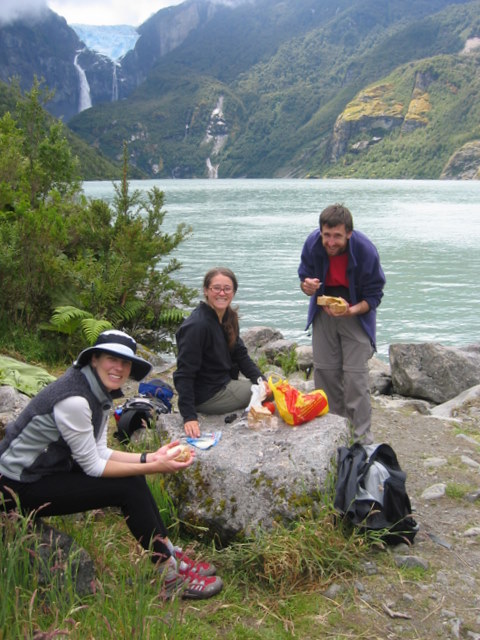
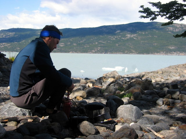
Instead of taking the 2 hour bus ride into the park from the nearest town, we elected for the all-day boat ride in. This began on a tour boat, visiting glaciers in nearby Bernardo O´Higgins Nat´l Park. After lunch at an "estancia" (ranch) now converted to hosting anglers and other tourist visitors, we continued by Zodiac up a glacier-fed river to a falls, hiked around the falls, and took a second Zodiac further up river into the park, tranferring to a van for the last few km to the park administration center. This was certainly less efficient than the bus ride from town to the same destination, but far more scenic.

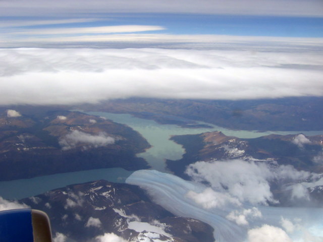
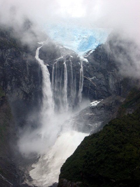
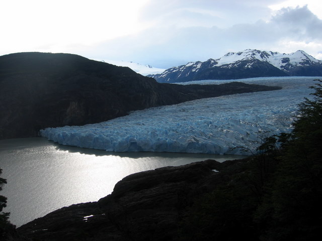
Receding glacier in Bernardo O´Higgins NP. (BOH commanded the forces that won Chile´s independance from Spain in the 1817. He was also Chile´s first dictator. [How was it that George didn´t become dictator of the newly independent colonies?] Every city, town, village, and hamlet here seems to have a street named after him.)

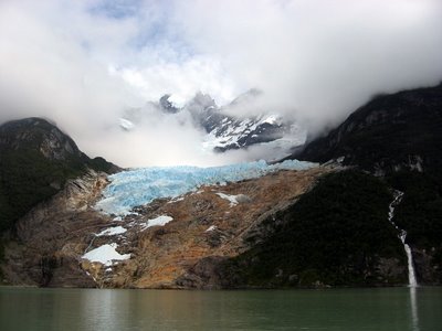
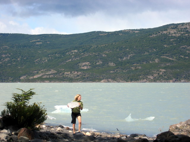
And another glacier. (Get used to seeing pictures of these. They were everywhere, and we couldn´t seem to stop taking photos of them.)

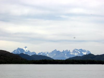
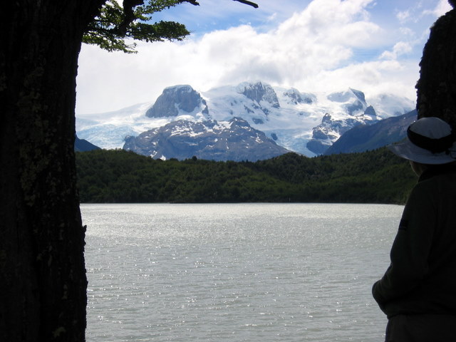
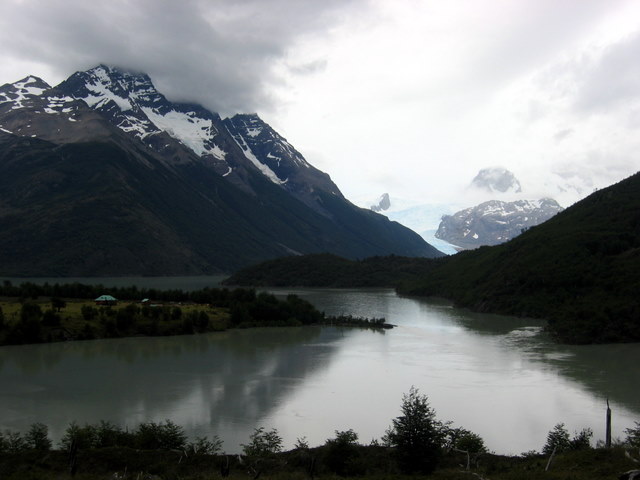
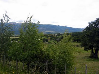
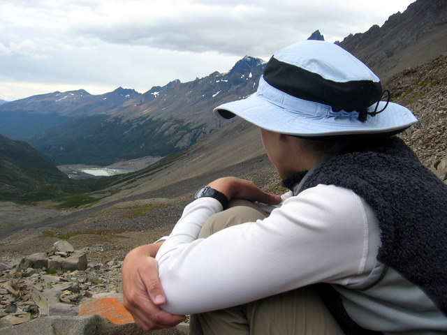
As our boat neared the park, we were treated to vistas of the mountain range in which we would spend our next several days. They are divided into the Paine Massif on the left, the Cuernos (Horns) roughly middle right, and a distant view of the actual Torres (towers) behind these.

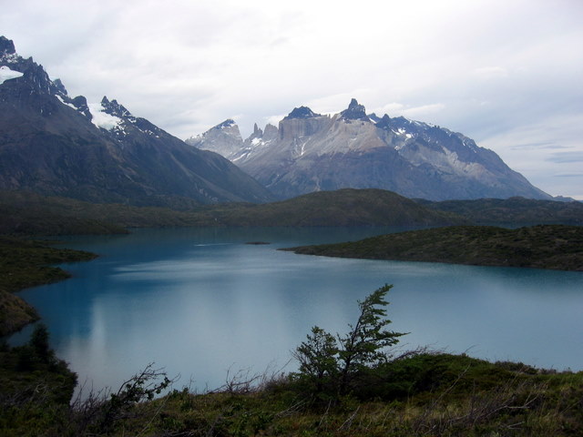
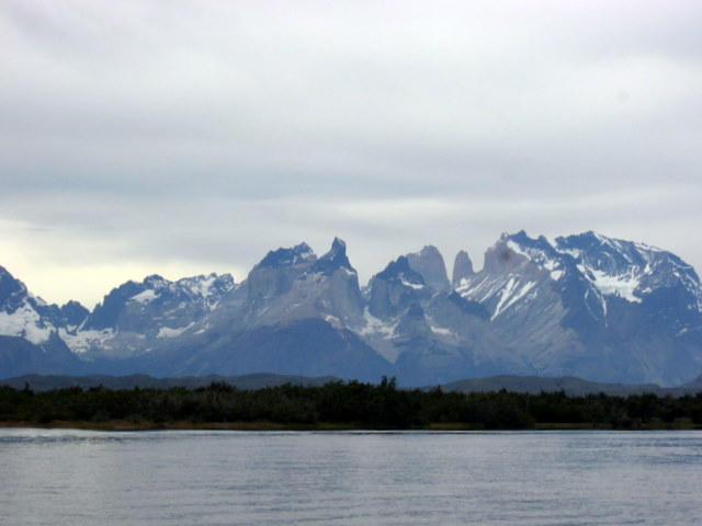
Closer view of the Cuernos and a Torre or two.

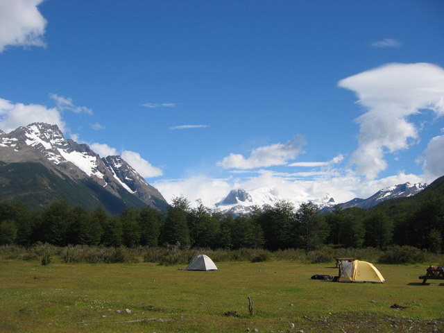
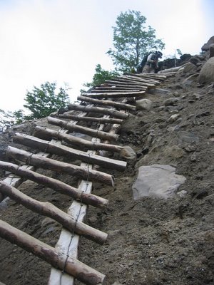
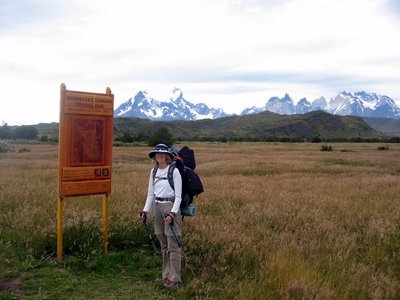
Finally, at about 5 p.m., we loaded up or packs and headed out on the trail into the long summer evening.

Wednesday, January 17, 2007

Coyhaique, Chile and Hielo Sur (the Southern Ice)

Coyhaique was our last stop on the Carretera Austral. The road continues almost as far south again, but at the last stop, the only alternative to backtracking is to take a ferry across a lake, then hike for two days to get to Argentina, in the region of the Fitz Roy Massif, passing through a remote customs and immigration checkpoint on the way. Word is that Chile has plans to extend the road all the way to Punta Arenas on the Strait of Magellan -- no mean feat, as this would involve skirting the Patagonia´s southern icefield (the Hielo Sur, which gives rise to a host of glaciers) and crossing the related fjordland with as many as a dozen ferries.

Coyhaique as a town was uninspiring, but the surrounding countryside was fabulous, as were the views on the bus ride down. We took a few photos on a walk out of town, and on the 50 km ride to the airport a few days later.


Then, from the plane south, we spotted the icefield peeking through a heavy layer a cloud. Unfortunately, there´s no way to do justice its size with a photo taken from the window of an airplane. It is the world´s 3rd largest icefield, after the Antarctic and Greenland ice caps. This photo shows the famed Perito Moreno Glacier, which we were due to visit on our way back to Buenos Aires much later.


Landing in Punta Arenas, we reached a the barren, windswept geography somewhat similar to tundra. It had its own beauty, but again, difficult to capture with just a photo from a bus window.

After a day´s preparation, our real wilderness adventure was to begin...

Friday, January 12, 2007

Puyuhuapi, Patagonia, Chile

We split our selected stretch of the Carretera Austral (see previous post for info) into two sections. Our first stop, Puyuhuapi, bears the distinction of being the smallest hamlet we anticipate visiting on our South American travels. We reached it after a six-hour bus ride from Chiaten. The single lane, gravel "highway" winds through fjord land covered in dense temperate rainforest. That, coupled with rainy weather, meant we didn't see all that much during the drive, and stepped out of our bus into rather drippy, dreary surroundings. Frankly, I wasn't sure I wanted to be in this village of 505 souls. They didn't even have Internet!!! (Yes, we're hooked. And they did -- supposedly -- have Internet, available to the public at one terminal in the corner of a cafe, but the connection was down and we didn't hear very good accounts of its operation when "up".)

Thankfully, the weather improved, and having esconced ourselves in the cheery Germanic surroundings of "Casa Ludwig", so did our mood.

This town actually has a rather fascinating history. It was established in 1936 by four young Germans from Sudetenland, the German portion of Czechoslovakia later annexed by Hitler. Because of the subsequent war, the planned emigration of more settlers from their village in Europe was forbidden -- all exit visas were cancelled by governments wanting to keep the young and able-bodied at home to bolster the military in the looming conflict. So these four gents cleared the land, built homes, and created, among other things, a custom rug factory. We are told that you can still send a design to be knotted into a personalized rug by Chilote women using hand looms. (We even met one tourist from the Bay Area of California who was travelling there to hand deliver his design.)

The last of these four intrepid pioneers passed away in 1996, and four classic Germanic homes remain in town as reminders. Casa Ludwig is one of these, and his daughter was our host! Jolene learned that she had been away at school in Germany during the Pinochet years, lived in Santiago for a time, then returned to run the hostel started by her mother in the 70's when the road builders needed lodgings. (Our room was the attic window at the top.)

South of Puyuhuapi lies Parque National Queulat. Like many in Chile, it's nascent infrastructure leaves much to be desired, but we enjoyed lovely hike over well-maintained trails to a hanging glacier. This glacier sported a snout into the lake below when the settlers first arrived, but has receeded since that time. The glacier's face played hide and seek behind the clouds, but paid us the courtesy of calving a couple of times (above) as we watched, sending "white thunder" rolling around the natural amphitheater.
The rest of the time, we just enjoyed the mesmerizing interplay of waterfalls and wind.

After our hike, we thought we would splurge on a "real" meal in Puyuhuapi's only fine dining establishment. We enjoyed a delicious meal, but whether from something in food or another of those interesting and too-friendly Chilean bugs, we spent that night and the next day prostrated by symptoms of stomach flu that I will not attempt to describe here. Thankfully, we managed to stagger our symptoms so that we could look after each other, and our host was happy to let us loll abed until we recovered.